

Methow Dark Sky Viewing Locations
The Methow Vally has some of the darkest skies in Washington State and the country. The stargazing locations below are a few places we like to go that are accessible by car with parking available. Perhaps there is a dark viewing location just around the corner from where you are as anywhere with a view of the night sky and away from town lights will be rewarding. Please respect private property and stay safe from traffic or other possible hazards.
Gunn Ranch Road
A short drive from Winthrop with dark skies and good views of horizon to the east, south and west. Can Park at the DNR parking lot (Lewis Butte) but the views are somewhat restricted, especially to the north. A short hike to knolls to the south finds improved views and a view overlooking the valley. There are also good views in many places along Gunn Ranch road especially before heading down toward the Gunn Ranch Ski Trailhead. The trailhead provides ample parking and good views to the north and south. Hike Lewis Butte (1100' vertical) for expansive views of the horizon.


Pearrygin Lake State Park
Pearrygin Lake State park is close to town, is accessible on paved roads, and has pretty good visibility in all directions. The park rangers often hold Saturday night interpretive star tours, staffing and weather permitting, starting in late July. Contact the park to confirm their plans.
The campgrounds make for fun family trips that can incorporate some dark sky viewing too.
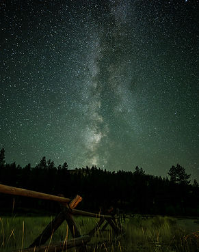
Sun Mountain
Great views in all directions and a nice spot for viewing northern lights. The image was taken from above the horse stall area and shy of the Sun Mountain Lodge.
The road is paved to Sun Mountain Lodge where this is parking available. There are a couple of pullouts on the way to the lodge as well.


Sweet Grass Butte
Sweetgrass Butte has very dark skies and an expansive view of the night sky. It is accessible by vehicle starting on Cub Creek road. The road turns to gravel after a couple of miles. The road is pretty good for a gravel road though passenger cars should consider parking at the base of the last short uphill stretch.
Harts Pass/Slate Peak
Harts pass/Slate peak is a bit of a drive but the dark skies and the expansive view don’t get any better than this. There are campgrounds near the pass to make a nice overnight star gazing trip. The Meadows campground has a concrete astronomy pad on top of a small knoll (~100m hike).
The road is narrow and very rough with lots of potholes and washed out areas. High Clearance, all Wheel Drive or 4WD are strongly recommended. Go slow and watch out for sharp rocks in the roadway! The steep dropoff near Dead horse point is not for the faint of heart. Closed to trailers during the summer.


Pipestone Canyon
This site offers good views, especially to the east and west. Views are somewhat limited to the north and southwest by ridges. The skies are relatively dark with little night time traffic. Informal camping may be found nearby.
From Winthrop, take East Side County Road for two miles and turn left onto Bear Creek Road (at golf course sign). After 2.3 miles, turn right on Lester Road; immediately after the pavement becomes dirt road. Follow this road to a flat, open area on the left immediately past a right hand turn to the Pipestone Canyon trail. Park at the informal parking lot.
Mazama Meadows
This spot offers a convenient location for night sky viewing in the upper Methow valley and Mazama. The view to the east is open, nearby ridges block the low horizon to the south, west and north.
Take highway 20 to the Lost River road leading to Mazama. The parking lot is east of the Mazama store and next to the Mazama Public house (an OSB place).


Twisp Soccer Fields
The Twisp Soccer fields offer a convenient location for viewing the night skies in all directions. While there are some lights from the town of Twisp and surrounding properties, good views of the night sky can be had.
From Highway 20 on the south end of Twisp, take Twisp Airport road 0.52 miles to a gravel road. Tun left on the gravel road north of the soccer fields and find parking on the road or at a parking lot. The gravel road around the fields is blocked but may also be accessed from the south. Observing on the soccer fields is not recommended since the sprinklers may come on at night.
Bear Creek Road
There are numerous good viewing points along Bear Creek Road where there are small pullouts and several parking area including by the shooting range and trail access for Lloyd Ranch trails. Pictured here is an old Silo which makes a nice foreground for Milky Way or Aurora photography. The turnout for this parking area is on a bend and the road and can be hard to see but look for the silo.

WA Pass Overlook
Visit the Washington Pass Overlook for a higher elevation view of the night sky far from any outdoor lights. Drive Hwy 20 from the east or the west and park at the Overlook parking lot just north of the pass. A short walk leads to the overlook. Liberty Bell and Silver Star mountains provide an impressive backdrop for your Milky Way Pictures. Views to the north and northwest are limited by the ridge.


Highway 20 Pullouts
There are several pullouts with safe parking just east of Washington pass along the south side of highway 20. These spots provide good views of Silver Star, Liberty Bell and Kangaroo ridge. While the sky is dark at this spot, passing traffic may interfere with your observing session.